Sunday’s weather: Good day for an egg hunt, sunny and breezy with a high of 51

Sign Up For Our FREE Daily eNews!

weather graphic 2 15

Sunday’s Weather

Easter Sunday morning will start with clearing conditions as low pressure departs to the east into the Maritimes and a drier, cooler airmass works in from the west. High pressure will allow for sunny conditions and milder temperatures tomorrow before clouds begin to increase by late afternoon.

Late-April Blast of Winter

A nor’easter will bring a late-April blast of winter. Most of the snow is expected to fall Monday night or early Tuesday when temperatures are the lowest. Most of the wet snow will have the potential for minor snow accumulations across the Monadnock Region and the hills west of Manchester and a nasty cold rain elsewhere late Monday into early Tuesday. The White Mountains could see 3-6″ of snow. 
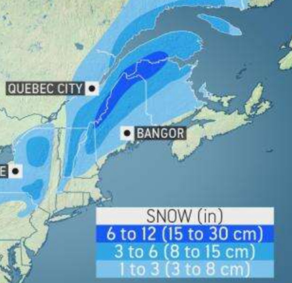
Screenshot 2022 04 16 7.30.48 PM

Potential exists for April snow early Tuesday, especially across elevations above 1,000 ft. and small track changes in the surface low will either increase or decrease the chance of accumulating snowfall. Please stay tuned over the coming days for potential travel impacts on Tuesday morning.


5-Day Outlook April 17-April 21

Easter Sunday: (Sunrise 6:01 AM) Cooler & breezy with sun & clouds. High 51 Winds: NW 10-20 mph
Tonight: Mainly clear. Low 36 Winds: NW 10-15 mph
Monday: Mostly sunny with increasing clouds in the afternoon. High 58 Winds: W 5-10 mph
Monday night: Clouding up with showers mixed with wet snow late. Low 37 Winds: ESE 5-10 mph
Tuesday: Early morning mix to rain. High 49 Winds: ENE to W 10-15 mph
Tuesday night: Partly cloudy. Low 39 Winds: W 10-15 mph
Wednesday: Mix sun & clouds. High 56 Winds: WNW 10-20 mph
Wednesday night: Partly cloudy. Low 38 Winds: WNW 5-10 mph
Thursday: Mostly cloudy and milder. High 63 Winds: SW 10-15 mph
Thursday night: Partly cloudy. Low 46 Winds: SW 10-15 mph

Weather Patterns We’re Watching

For the second half of next week, a stretch of cool and calm weather is on the way for New England. By next weekend, however, there can be moderation in temperatures or even a warmup as high pressure takes hold.


Be an Official Ink Link Weather Spotter!

Rick Gordon could use your help. If you are interested in becoming a local weather spotter (all locations around NH) contact Rick at gordonwx@comcast.net and he’ll walk you through the process!

FullSizeRender 12
Winter Weather Watcher says: You, too, can be a weather watcher.

Ski Report via Ski NH

Screenshot 2021 12 29 6.57.28 PM e1640822371343

Summits above 4,000 feet in Northern New Hampshire Today:
Summits obscured. Numerous snow showers in the afternoon. Highs in the lower 30s… except in the mid-20s at elevations above 5000 feet. Northwest winds around 25 mph increasing to around 40 mph in the afternoon. At elevations above 5,000 feet, northwest winds around 35 mph increasing to around 55 mph in the afternoon. Chance of snow 70 percent. Wind chill values as low as 6 below.
Elevations between 2,500 and 4,000 feet in Northern New Hampshire Today:
Summits are obscured in the morning, then summits in and out of clouds. A chance of snow showers in the morning, then numerous rain showers and snow showers in the afternoon. Highs in the mid-30s. Northwest winds around 25 mph increasing to around 35 mph with gusts up to 45 mph in the afternoon. Chance of precipitation 70 percent. Wind chill values as low as 6 above.

Check out slope conditions below


About this Author

Rick Gordon

Rick is a native of Red Hill, PA, and is a former Chief Meteorologist at WMUR-TV. He currently teaches ninth-grade physical science at Central High School. His past adventures in weather-watching include a stint as on-air meteorologist for WSEE in Erie, PA; meteorologist with D&M Weather Services in Pittsburgh, PA; AccuWeather in State College, PA; and weather guy for KDKA radio in Pittsburgh. He studied meteorology at Millersville University in Lancaster, PA (aka God’s Country) and currently lives in Wells Beach, Maine. 

Twitter